
China is developing a new generation of satellites for its BeiDou system that will give unprecedented accuracy and coverage for a range of services, including mobile phone access, according to the programme chief.
China is developing a new generation of satellitesfor its BeiDou system that will give unprecedented accuracy and coverage for a range of services, including mobile phone access, according to the programme chief.
Ran Chengqi, director of the China Satellite Navigation Office, said the new global positioning system, tentatively named BeiDou 4, would extend its services to include underwater communications and deep space.
The satellites would use new technologies, including more precise atomic clocks, to further increase BeiDou’s positioning accuracy – already on a par with the US military’s GPS, Ran said in Beijing on Friday.
Ran said China planned to launch three to five more BeiDou satellites next year to test the new technologies and their integration with the mobile phone communication network.
“Our plan is to complete the construction of this new generation of satellites system by 2035. No matter where you are in the world, at any moment, you will have access to the secure, reliable time-space technology provided by BeiDou from China,” he said.
BeiDou – which means Big Dipper – is the largest timing and guidance network, with 45 satellites in service.
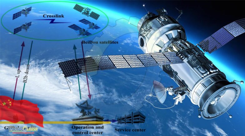
BeiDou-3 version satellites, are already equipped with technologies so far unavailable to other countries, including Earth-observation sensors and high-speed laser communications.
Astronauts on board China’s just-completed Tiangong space station are testing the most precise atomic clock in orbit. If successful, some of their findings could be used to boost the performance of BeiDou’s new generation of satellites, said scientists involved in the project.
The Chinese military has also funded a number of research projects to develop cross-medium communication technology that would allow submarines or drones to receive BeiDou signals underwater.
There are also plans to use BeiDou signals to guide orbital hypersonic flight and the construction of settlement infrastructure on the moon and Mars, according to openly available information.
“We hope that no matter if it is underwater, on the ground, indoors, in the air, or even in deep space, China’s space-time system will always be there,” Ran said.
BeiDou 1 was launched in 2000 with just two satellites, emitting low-quality positioning signals – that could be off by tens of metres – to a small region, mostly within China.
By the time it was completed in 2020, the system had improved enough to give global users an accuracy of about 5 metres (16.4 feet).
Ran said the precision of BeiDou’s guiding signal had now reached a few centimetres in a number of Chinese cities.
Increasingly, the BeiDou signal was being used to improve performance in hi-tech sectors including autonomous driving, drones, high ultra-high voltage power transmission, unmanned ports and natural disaster alerts, he said.
According to Ran, some smartphones can now send text messages via the satellite from remote areas without telecommunications services. Soon, with BeiDou’s help, they would be able to receive messages as well, he said.
“You feel secure [because] you are forever online.”
More than half of the world’s countries have officially adopted BeiDou for timing and positioning, according to Chinese government data.
Ran said more companies were using the Chinese satellites to track cargo movements between China and other parts of the world, including Europe.
“In Saudi Arabia, BeiDou has found some critical applications, such as the collection of surveying and mapping geographic information, urban municipal infrastructure construction, personnel or vehicle positioning in the desert,” he said.
The BeiDou system is also providing real-time continuous monitoring, with an accuracy of millimetres, of Tajikistan’s Sarez Lake dam which was formed by an earthquake in 1911 and risks collapse from further seismic activity.
Similar services were used in the construction survey of the Beirut port terminal in Lebanon, Ran said.
“We have also carried out stronger and closer cooperation with Russia with the signing of a strategic cooperation framework agreement to strengthen collaboration [by 2025] in many fields including highway transport and cross-border cargo flow,” he said.
Originally published at South China Morning Post