UNESCO World Heritage Sites (WHS) across the globe have faced a considerable increase of hazards in recent decades as a result of earthquakes, climate change, management challenges, urban sprawl, and agriculture. Damage assessments frequently failed to deliver a complete picture and detailed information on the extent and types of risks at heritage sites in the world. This situation is also well reflected at Pakistan’s World Heritage Sites, where potential risks exist that threaten their conservation at the heritage sites.
By Dr.M.Younis Khan,Dr. Federico Zaina
This present study has adopted a tailor-made methodology for documenting risks to cultural heritage sites that integrates space-borne and ground-based remote sensing (Horizontal-to-Vertical Spectral Ratio (HVSR)) techniques. The research tested its effectiveness and feasibility at the three UNESCO World Heritage Sites of Taxila, Pakistan. A cost-effective and time-effective methodology was designed, which was easy to apply by local authorities, and will assist in improving both national damage assessment protocols and the UNESCO state of conservation reports elsewhere.
Therefore, hazard to global heritage have only been partially resolved by academic research and grey literature, which generally focusing on random World Heritage Sites and targeting single or few factors, thus offering a limited picture on the overall situation at each site. A perfect example reflecting these pressing issues is the World Heritage Site of Taxila, Pakistan. This site has a long history spanning over 8000 millennia, from the Neolithic tumulus of Saraikala to the ramparts of Sirkap (2nd century BCE). It is situated on a branch of the Silk Road that linked China to the West and it currently comprises of 18 heritage properties scattered over an area exceeding 100 Hectares. Taxila has been considered as a key Buddhist centre of learning for centuries while the Bihr mound is associated with the historic event of the entry of Alexander the Great into the city. After having been abandoned for a thousand years, the city was rediscovered during the 19th century CE by explorers, and then systematically investigated by John Marshall between 1910’s and 1930’s.
The outstanding discoveries opened a new chapter in the history of the site, eventually leading to its declaration as UNESCO World Heritage Sites in 1980. Apart from human-made activities, cultural heritage sites are also vulnerable to extreme natural catastrophic events. For example, earthquakes have caused considerable destruction to heritage sites in South Asia and across the globe throughout the human history.
Ongoing collisional movement of the Indian Plate northwardly at a rate of about 40–45 mm/yr with the Eurasian Plate has resulted in build-up of seismotectonic stresses in the region, and hence the study area one of the most seismically active regions of the world. the research study used the historical (extending back to 25 CE), and instrumental records to understand the seismic hazard potential of Taxila for a possible impact on the World Heritage Sites and its immediate surroundings. Although the historic events are infrequent but very destructive in nature, for example, the historic earthquake of 25 CE ruined the civilizations and devastated the infrastructure and livelihood. Taxila earthquake has Modified Mercalli Intensity level IX in close proximity of Taxila (about 25 km west-northwest of Islamabad), which destroyed Buddhist monasteries. In the recent past, the 2005 earthquake of magnitude 7.6 is the best example of which Bagh-Balakot Fault (BBF) was the causative fault, shook the whole region, and thereby represents the rich seismological environment around the study area. In addition, there are several local faults located in close proximity of WHS especially the Margalla Trust Fault that runs through the World Heritage archaeological sites. So far, no geophysical and remote sensing studies have been carried out at the World Heritage Sites. Therefore, this research has presented an updated assessment of the damages to Taxila by an integrated approach based on spaceborne and ground-based remote sensing techniques. The proposed methodology offers several advantages over the traditional archaeological surveys due to their time, cost effectiveness and especially non-invasive nature that is always a pre-requisite to avoid any damage to heritage site.
Satellite remote sensing (RS) represented a game-changer in the way archaeologists and heritage experts analysed endangered archaeological sites. Its use has been enhanced by the availability of online open-access spaceborne imagery through platforms such as Google Earth Maps. This work presents multi-temporal satellite imagery of the selected area to target final users (archaeologists, local and national heritage authorities etc.) without in-depth knowledge of advanced RS tools. It is divided into three steps: 1. Data collection, meaning the gathering of high resolution open-access satellite imagery from 1970s until today; 2. Data processing, that is the correlation of archaeological and geographic data to classify the types of damages to the three case studies and then to reconstruct their destructive trend over the last 40 years. We used manual identification approach in spite of growing number of both automatic and semi-automatic methods of sites and damage identification because it still represent the most probable and simplest of the exploitation scenarios by field archaeologists as well as officers from local and/or national cultural heritage institutions that the present work aspires to reach and encourage towards the use of satellite data; 3. Results, consisting in the analysis of the damage for each of the three areas of Taxila along with their evolution from the late 1970s until 2020s.
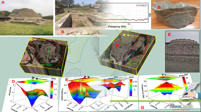
The horizontal-to-vertical spectral ratio (HVSR) geophysical method has extensively been used in geohazard related studies. However, it has rarely been employed in archaeological studies. Owing to the location of World Heritage Sites in a seismically vulnerable Taxila city and their cultural importance, there is a strong need for the HVSR investigations to evaluate its seismic vulnerability. For the first time, this work presents seismic microzonation study at heritage-scale aimed at targeted hazard mitigation actions at Taxila, Pakistan. The HVSR results demonstrated the site effects sites through quantified spectral features (amplitude and frequency). The spectral characteristics of HVSR curves (flat to broad to well-defined single- and multiple frequency peaks) may further confirm the complex dynamic behaviour of WH sites, which can be related to the numerous lateral heterogeneities in the subsurface. The heritage-scale microzoning demonstrate the impact of the seismic site-effects on the stability of aged and weakened remains at Taxila WH sites in terms of seismic safety. Some of the WH sites (Sirkap) displayed seismic amplification, while little or no such phenomenon observed at others (Mohra Moradu). This amplification can considerably enhance the archaeological structure’s seismic vulnerability in case of earthquake. It may lead to partial damage or complete collapse of walls and/or stupas due to their aged, weak, and use of heterogenous construction material after being subjected to numerous reconstruction phases. Owing to its location, local and regional seismic sources may put Taxila WH sites at serious risk by causing irreparable and unquantified loss in case of earthquake. The repair of heritage sites of universal value is much higher when compared to the residential buildings. In a developing country like Pakistan, local communities and/or national heritage organizations cannot afford the costs of repair involved. Having said that, there is a strong need for urgent and detailed seismic hazard assessment that may provide useful information on the seismic vulnerability of the WH sites. The results may further guide in accelerating and prioritizing the repair work of a specific part(s) of a WH site that is in need of interventions, and where no site information has been considered in the past.
In order to provide a step forward in the understanding of the damages to Taxila from the initial causes to the final effects we applied a Silent Risks VS Loud Risks approach, is based on the state-of-the-art idea, that certain types of threats such as natural hazards, looting and conflict-related destruction while being of the utmost importance, have been over-considered by academic researches and the media, overshadowing other types of damage equally or more destructive like ploughing, urban sprawl and road construction.
In the case of Taxila, we identified building, ploughing, levelling, lack of vegetation control as Silent Risks. Both building and levelling, represented at Taxila an issue affecting almost half of the case studies considered over the last 10 years. More apparent is the impact of ploughing, which represents the most extensive type of damage. Lack of vegetation control exceeds 15 ha and together with ploughing, is the main issue observed. Loud risk included earthquake and decay. The lack of effective management strategies resulted in the structural decay experienced especially at Sirkap and Dharmarajika. But what is really surprising amongst the loud threats is that earthquake, one of the most studied threats, has been totally neglected before. As demonstrated by the HSVR analysis this is an important issue that deserve attention in the future.
Different monitoring and conservation activities have been conducted at Taxila after its declaration as UNESCO World Heritage Site in 1980. Four official UNESCO reports have been issued from 1995 to 2013. This trend was also highlighted by other institutions such as the Global Heritage Fund which identified Taxila as one of 12 worldwide sites most “On the verge” of irreparable loss. In the same year, another team highlighted numerous issues including the lack of a management plan, and access to several areas as well as the threats caused by climate change.
This article has presented an integrated approach combining state-of the-art user-friendly, time and cost-effective ground-based and remote sensing techniques to assess the risk due to anthropogenic and environmental factors at Taxila. The results improved the current understanding on the state of conservation and the damages to the site provided by previous UNESCO SOCs. Based on this article results, the proposed methodology can find applications in Pakistan and elsewhere in the world. Indeed, despite their efficiency and usability by users without in-depth knowledge both in Remote Sensing and HSVR like archaeologists, local and national heritage authorities, both approaches still face a limited diffusion and application at global level. These may eventually foster the spread of this methodology especially amongst authorities that are responsible for protecting sites:
- It is important to hold training sessions for local heritage officials to learn about UNESCO ideas and requirements, as well as how to use Google Earth. The trainings should give participants a customised image of the many satellite datasets accessible, which may differ from nation to country. The Hexagon KH-9 in our case study, for example, does not have worldwide coverage and might be substituted by other sets of historical spaceborne photography, such as the CORONA missions and high-resolution aerial imagery.
- To monitor the status of preservation of Taxila, the remote sensing methodology should be strengthened by integrating a satellite imaging analyst in the team. A satellite imaging analyst typically has a thorough understanding of space engineering as well as archaeology and conservation techniques. Collaborations between imagery analysts and archaeologists or cultural heritage experts are becoming more common examples worldwide and should be adopted in Pakistan.
- In seismically active zones, where World Heritage Sites are potentially susceptible to threats ranging from ploughing, vegetation, construction activities, landslides, and earthquakes, integrating remote sensing methods with ground-based geophysical HVSR is critical. At the heritage scale, HVSR-derived seismic microzonation maps aided in the identification of sites and individual zones at subject sites that could be severely damaged in the event of a future earthquake. This information could be very beneficial in prioritising specific places within a site where urgent repairs are required.
- Both UNESCO and local governments must make a stronger commitment. More efforts should be made in this regard, as earlier SOCs did not completely acknowledge the damage and did not adequately implement the UNESCO methodologies. The authorities at Taxila, for example, may follow the approach other World Heritage Sites, where SOCs are created jointly by UNESCO and the hosting country.
- Researchers and local governments should devise programmes to promote public knowledge about the significance of Taxila historic monuments. This could be accomplished using community-based archaeological initiatives, which could help, for example, to minimize the damage caused by locals in Sirkap’s agricultural area.
These recommendations and the results of our research will be shared with local, national and UNESCO authorities in Pakistan. Furthermore, to strengthen this study approach, the academic researchers may test and possibly improve it on the remaining UNESCO sites in the country.
Authors:
Dr.M.Younis Khan
Dr. Federico Zaina
The Principal Author of this research article is working as Assistant Professor at National Centre of Excellence in Geology, University of Peshawar Pakistan.