
Pakistan has many rivers. Read on to find out more about these rivers. The Name Punjab comes from words panj for five, aab for water.
Pakistan is a country with some of the world’s most beautiful cities, landscapes, and structures from history. A lot of natural resources as well. There are majestic mountains, beautiful seaside views, and lush green plains and meadows here. It has one of the best educational systems and healthcare systems in the world. Pakistan has a lot of rivers. Read on to find out more about five rivers of Pakistan.
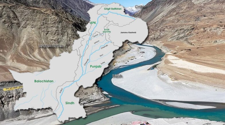
The Himalayan and Karakoram mountain ranges, which are covered in snow, feed Pakistan’s river system. The system is made up of five rivers that mostly flow to Pakistan through Punjab province. The name Punjab comes from the words “panj” for five and “aab” for water. These are Pakistan’s five rivers:
- River Jhelum
- River Chenab
- River Ravi
- River Sutlej
- River Indus
1. River Jhelum
In northern India and eastern Pakistan, the Jhelum River, which is one of the most important rivers of Pakistan, flows through the Kashmir Valley. It is a branch of the Chenab River that runs for about 725 km (450mi).
There are a lot of interesting stories about the river’s past. Some people say that “Dara-e-Azam” planted his flag on the riverbank and called it “Ja-e-Alam,” which means “place of the flag,” when he got to the river after a series of wars. As time went on, people began to call “Ja-e-Alam” “Jhelum.”
Some people think that the name of the river comes from the Sanskrit language. The name of the river comes from a story that everyone knows. People say that Lord Shiva named the river Vitasta. In the holy texts called the Rigveda, it is called one of the great rivers.
In BC 326, at the Battle of the Hydaspes River, Alexander the Great and his army crossed the Jhelum and beat Porus, the leader of the Indians.
The river starts at the Verinag Spring, which is at the base of the Pir Panjal in Kashmir. Then, in the Kashmir Valley, the Lidder River near Khanabal and the Sind River at Shadipora join it. It goes through Srinagar and Wular Lake before going into Pakistan. East of Circle Bakote, the Kohala Bridge links it to the rest of Pakistan and to Pakistani Kashmir. The Poonch River then joins it and flows into the Mangla Dam reservoir in the Mirpur District.
2. River Chenab
Pakistan is a country with a lot of beautiful places to see and things to do in nature. Pakistan has everything: huge mountain ranges, green plains, and beautiful deserts. Like the Jhelum River, the Chenab River runs through both India and Pakistan. It starts in the Lahaul and Spiti districts of the Indian state of Himachal Pradesh, in the upper Himalayas. It flows through the Jammu area of Jammu and Kashmir and into the Punjab plains of Pakistan. Near Uch Sharif, it joins the Indus River.
During the time of the Vedas, Indians knew about the river. In 325 BC, Alexander the Great built Alexandria on the Indus. This city is now called Uch Sharif. When the Jhelum and Ravi rivers meet, they make the Chenab. When the Beas and Sutlej rivers meet, they make the Panjnad. This is near Uch Sharif. About 45 kilometres to the southwest, at Mithankot, the united stream joins the Indus River. The Arabian Sea is at the end of the Indus River.
3. River Ravi
The Ravi River runs through the northwest of India and the east of Pakistan. It is also one of the six rivers in Punjab that are part of the Indus System. Under the Indus Water Treaty, India was given water from the Ravi River. In the same way, the Indus Basin Project used water from the western rivers of the Indus system to refill the Ravi in Pakistan.
The Vedas say that in the past, the Raavi River was called Iravati. The headwater of the Indus River Basin is the Ravi River. It is one of the most important parts of the basin. If you like learning about the past, you should visit Historical Sites in Pakistan.
The water from the Ravi River flows into the Arabian Sea by way of the Indus River in Pakistan (Indian Ocean). The river starts in the Bara Bhangal district of Kangra in the Indian state of Himachal Pradesh. After going through India for 720 km (450mi), the river drains an area of 14,442 square km (5,576 sq mi).
The Ravi River is also important for plants in Pakistan. Some of the plants it is responsible for are Deodar, walnut, Quercus ilex, mulberry, alder, edible pine, twisted cypress, chinar, Cedrela Serata, Sisso, olive, and Kakkar.
If you plan to go to River Ravi, don’t forget to stop by some of Lahore’s other picnic spots.
4. River Sutlej
The longest river among the rivers of Pakistan is the Sutlej, which starts in the province of Punjab. It is a river that flows through both India and Pakistan, in the north of each country. In the language of the people who live there, the Sutlej River is called Satadree. The Sutlej starts west of where water flows into Lake Rakshastal in Tibet.
The waters of the Sutlej are given to India by the Indus Waters Treaty between India and Pakistan. Upstream of the Ropar barrage, which is across the Sutlej River from the Bhakra dam, the river flows about 14 million acre-feet (MAF) per year.
The Sutlej River is very important to Pakistan because it helps make hydroelectricity. The Sutlej River is used for many hydroelectric projects in Pakistan. Some of the projects are the Bhakra Dam (1,325 MW), the Karcham Wangtoo Hydroelectric Plant (1,000 MW), and the Nathpa Jhakri Dam (1,500 MW).
5. River Indus
The Sindhu River is another name for the Indus River. The Indus River was known to ancient Indians as Sindhu and to Persians as Hindu, and it was considered “the boundary river” by both of them. It is one of Asia’s most massive rivers. The river flows through western Tibet in China, Ladakh in India, and Pakistan. The river Indus flows through India’s Ladakh region to Gilgit-Baltistan, where it mixes with the Arabian Sea.
The river has a drainage area of more than 1,165,000 km2 (450,000 sq mi). Its yearly flow is estimated to be roughly 243 km3 (58 cu mi). The river’s geography is very fascinating. It all begins with the Himalayan mountain springs and glaciers, as well as the Karakoram and Hindu Kush ranges.
The Punjab area is formed by the northern half of the Indus Valley and its tributaries, whereas Sindh is formed by the lower course of the river and finishes in a vast delta. The Indus River is a vital source of water for Pakistan’s economy, particularly in Punjab province, which produces the majority of the country’s agricultural output.