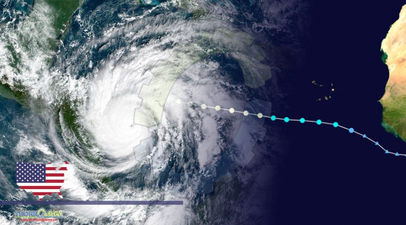
National Hurricane Center in the United States said via NASA Images Hurricane “Larry” had strengthened into a category two hurricane and that more intensification of the hurricane is expected in the next couple of days.

On its Twitter account, NASA posted images of Hurricane Larry; its astronauts spotted from the International Space Station.
A Teller Report specified that earlier, the National Hurricane Center in the United States said via NASA Images Hurricane “Larry” had strengthened into a category two hurricane and that more intensification of the hurricane is expected in the next couple of days.
More so, the Center added, “Larry” is anticipated to turn into a major hurricane during the weekend. Hurricane Larry occurs days following Hurricane Ida, which has left more than 40 people dead thus far.
Essentially hurricane Larry stayed a major hurricane late Sunday was located well east of any land. Earlier on, on Friday evening, it strengthened into a Category storm, a UPI report said.
‘Larry’ Retaining Its Strength
Earlier today, it was reported that the NHC, in its late evening update said, the eye of the storm was situated approximately 785 miles east-northeast of the northern Leeward Islands and roughly 1,135 miles southeast of Bermuda.
The hurricane had 125 mph sustained winds and moved northwest at 12 mph. The NHC also said in its update that Hurricane-force winds are extending outward up to 70 miles.
Hurricane Larry was not close to land, and there were no warnings, neither watches, taking in effect. It is expected to stay a major hurricane through the middle of this week, although a slight change in strength is forecast during the next couple of days, through fluctuations in strength is probable.
Swells that Larry generated, the NHC explained in its advisory, are reaching the Lesser Antilles, not to mention, are anticipated to spread westward to parts of the Greater Antilles, the Bahamas, and Bermuda early next week.
Substantial swells need to reach the east coast of the US and Atlantic Canada by the middle of this week. Such swells are predicted to result in life-threatening surf and rip present conditions.
A Large Intensify Hurricane
Larry was situated roughly 830 miles east of the Northern Leeward Island on Sunday afternoon, moving towards the northwest at 13 mph.
Maximum sustained winds were recorded at 125 mph, with higher guts, said the NHC adding, a slight change in strength is predicted during the next couple of days, even though fluctuations in strength will be possible.
Describing hurricane Larry, the center said it is a “large hurricane.” It also said hurricane-force winds are extending upward up to 45 miles from the center. Tropical-storm-force winds, on the other hand, are extending outward up to 175 miles.
Even Stronger Than Ida?
USA TODAY earlier today reported that according to Accuweather meteorologists, Larry, currently a Category 3 hurricane, could intensify into a stronger Category 4 storm, possibly by Sunday.
A Category 4 hurricane, as Ida was when it landed in Louisiana, has sustained 130 to 156 mph winds.
Essentially, the sustained winds rise above 150 mph; it would turn into the strongest storm this year in the Atlantic, which, the Accuweather claimed, is even stronger than Ida.
Accuweather also said the storm was expected to stir through the Atlantic’s waters for several more days, although it could eventually reach Bermuda around mid-week and move near North America.
The weather bureau also said, at this point, it is most possible that Larry will miss the US and stay a few hundred miles away from the Northeast coast.
Meanwhile, according to the hurricane center, still, much of the eastern US coast could feel the impacts of Larry by the middle of this week.
Source Science Times