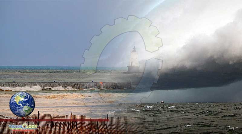
A wave of water known as a meteotsunami surged across Lake Michigan and damaged homes and boat docks in the beach town of Ludington.

A wave of water known as a meteotsunami surged across Lake Michigan and damaged homes and boat docks in the beach town of Ludington, Michigan, USA almost exactly three years ago.
Now, scientists say it was the first of its kind ever documented in the Great Lakes.
Identified through photos and video, experts had already determined it was a meteotsunami, named because such waves are generated by meteorological conditions versus the seismic activity that causes more well-known tsunamis.
A meteotsunami event isn’t uncommon in the Great Lakes. Usually, such waves are generated by a change in the atmosphere combined with wind. But the April 13, 2018 wave was the first-ever event known to have occurred without the influence of wind.
Not only does that make it unique, but it also opens the door for forecasters to be able to predict such events in the future, according to Eric Anderson, a physical scientist who specialises in hydrodynamics and forecast models at NOAA’s Great Lakes Environmental Research Laboratory.
The discovery and its potential implications for forecasting are detailed in a study by Anderson and colleague Greg Mann, published in the journal Natural Hazards.
Meteotsunamis occur around the world, but until now, scientists believed it took two ingredients for one to form on the Great Lakes: a spike in the wind and a jump in pressure.
“In the Great Lakes region that generally means things like thunderstorms or squall lines,” Anderson said. “When those come across the water they have outflows with high wind speeds associated with the front of them and they also often have pressure changes associated with them, too. Through both of those mechanisms, we can get large meteotsunami waves that are initiated in the Great Lakes.”
On the ocean, though, meteotsunamis are generally driven only by atmospheric disturbances that have a big pressure jump associated with them, Anderson said.
“This event we had in 2018 was just that,” Anderson said of the environment that created the Ludington meteotsunami. “It was a series of atmospheric pressure waves that were generated over the Midwest and moved east northeast over Lake Michigan and had about a 12 millibar pressure change associated with them, so a very large pressure change in just a few minutes.”
Forecasters currently have no way to predict meteotsunamis in the Great Lakes. But Anderson said this discovery could change that, at least when it comes to waves that don’t involve wind. That’s because short-range weather models can more easily detect atmospheric pressure waves, while thunderstorms are harder to anticipate.
“Right now we don’t have an alert to tell people (a meteotsunami) is coming,” Anderson said. “If we had the ability to forecast this, we could say conditions are dangerous in the nearshore during this time or this location, just like we can put out for things like rip currents or other features that might be a danger.”
The discovery might never have happened if not for Ludington resident Debbie Maglothin, who shot images of the wave as it rushed between breakwaters and flooded the shoreline.
“That meteotsunami was hands down off the chart awesome,” Maglothin said, according to a news release from NOAA. “The water in between the breakwaters didn’t go down like the water on the outside of them, so it created waterfalls that cascaded over the breakwaters. Had this event occurred during summer it could have washed people right off the breakwaters.”
A meteotsunami in 2013 washed three people off a jetty in New Jersey.
Eight people were killed after a large wave surged over the shores of Lake Michigan in Chicago in 1954. Decades later, the wave was identified as a meteotsunami, according to the Chicago Tribune.
The 2018 event produced a 6-foot wave. That’s considered a higher-end meteotsunami that happens about once a decade.
“The real danger here is that’s a lot of water being pushed in over a matter of generally 10 to 20 minutes,” Anderson said. “So you have all this water being pushed in the nearshore and then retreating, a very rapid flood is generally what that looks like. But along with that comes dangerous currents and all kinds of conditions that can cause trouble.”
A 2019 study that looked at 94 deaths and 298 rescues attributed to rip currents at Lake Michigan beaches over 15 years determined that 16% of the deaths and 12% of the rescues happened on the same day as a meteotsunami, according to the Tribune.
Anderson said it was luck that the 2018 wave happened early in the season.
“It was still very cold, some ice was even out there on the lake, so nobody was out there” he said. “That was fortunate because if that happens in July, that event probably leads to fatalities.
Originally published at Weather