
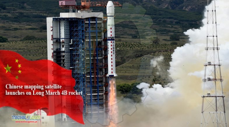
An Earth observation satellite designed to collect three-dimensional mapping imagery rode a Long March 4B rocket into orbit Sunday with three smaller spacecraft, including one to test an innovative French-made iodine thruster, and another satellite built for Sudan.
Hailed as a milestone in cooperation between European and Chinese space industries, the French thruster was made by a Paris-based startup named ThrustMe. Integrated into a briefcase-sized 6U CubeSat, the propulsion system is the first of its kind to be tested in space, officials said.
The primary payload launched Sunday was Gaofen 7, the latest in a series civilian-operated Chinese Earth observation satellites. Gaofen 7 is China’s first civilian-use optical surveillance satellite capable of collecting three-dimensional images with better than one-meter (3.3-foot) resolution, according to the China National Space Administration.
Two other small satellites were aboard Sunday’s launch: Huangpu 1, a technology demonstration satellite for a planned constellation of low Earth orbit satellites, and the Sudan Scientific Experimental Satellite.
The four satellites lifted off at 0322 GMT Sunday (11:22 p.m. EDT Saturday) from the Taiyuan space center in northeastern China’s Shanxi province, according to the state-run Xinhua news agency.
A 15-story Long March 4B booster carried the satellites into orbit. The three-stage rocket delivered the quartet of payloads into a near-circular polar orbit roughly 310 miles (500 kilometers) above Earth, with an inclination of 97.5 degrees to the equator, according to U.S. military tracking data.
Chinese officials declared the launch a success.
The Xinhua news agency said the Gaofen 7 satellite, the largest spacecraft on Sunday’s launch, was developed by the China Academy of Space Technology, a state-owned contractor in the Chinese space program.
Gaofen 7’s high-resolution optical imager and laser altimeter will gather precise topographic data, officials said.
The Chinese Ministry of Natural Resources, the Ministry of Housing and Urban-Rural Development and the National Bureau of Statistics will be the main users of Gaofen 7 satellite data, according to Xinhua.
The Gaofen satellites, which began launching in 2013, are part of the China High-Resolution Earth Observation System, or CHEOS. Chinese officials say the CHEOS satellite fleet is a civilian-operated program comprising optical and radar imaging spacecraft, and authorities have published high-resolution imagery taken by previous Gaofen satellites.